Garmin Foretrex 201 Manual
Læs nedenfor 📖 manual på dansk for Garmin Foretrex 201 (2 sider) i kategorien Navigator. Denne guide var nyttig for 13 personer og blev bedømt med 4.5 stjerner i gennemsnit af 2 brugere
Side 1/2
QUICK START GUIDE
Using the Map Page
The Map Page shows where you are (the animated figure)
and provides a picture of where you are going. As you travel, the
animated figure ‘walks’ and leaves a ‘trail’ or ‘track log’. Waypoint
names and symbols are also shown on the map.
Map Page
To use the Map Page while moving around:
1. Press the PAGE button until the Map Page is displayed.
Press the DOWN button to zoom in for a more detailed view of
the map. Press the UP button to zoom out for a view of a larger
map area.
2. Walk or drive around for a few minutes, make a right or left
turn, then continue for a few more minutes and stop.
Marking a Waypoint
Waypoints are locations or landmarks worth recording and stor-
ing in your GPS. These are locations you may later want to return
to, such as check points on a route or significant ground features
like your campsite or a favorite fishing spot.
Waypoints may be defined and stored in the unit manually by
taking coordinates for the waypoint from a map or other refer-
ence. This can be done before ever leaving home. Or more usually,
waypoints may be entered directly by taking a reading with the unit
at the location itself, giving it a name, and then saving the point.
To mark your current location as a waypoint:
1. Press and hold the button for two seconds ENTER/MARK
to display the Mark Waypoint Page. Your current location is
marked as a waypoint and assigned a three-digit number.
2. The ‘OK’ button is highlighted so press the ENTER/MARK
button again to save the Waypoint.
Navigating to a Location
Basic navigation with your Foretrex requires only three steps:
mark move return, , and . Mark your location as a waypoint, move
a distance away, and then return after choosing one of several meth-
ods, such as using a GoTo or following a virtual breadcrumb trail.
To return to a waypoint using the GOTO button:
1. Press the GOTO button to display the GoTo Waypoint Page.
2. Use the UP DOWN and buttons to select the desired tab and
press .ENTER
3. Use the UP DOWN and buttons to select the waypoint you
would like to route to and press .ENTER
The Navigation Page automatically displays to lead you to the
waypoint.
Using the Navigation Page
The Navigation Page helps guide you to a destination: Just follow
the arrow in the center of the compass.
Navigation Page
To use the Navigation Page to get to a destination:
1. With a destination already selected and a navigation started,
press the PAGE button repeatedly until the Navigation Page is
displayed, if it is not already.
2. The Navigation Page displays a Pointer indicating the direction
to go. Because you can’t always travel in a straight line, refer
to the Pointer from time to time. As you move and whenever
possible, turn in the direction the Pointer directs until it points
straight up. At which time, travel forward until you arrive at
your destination.
3. To stop navigating, press the ENTER button while on either
the Map or Navigation page. Use the buttons to UP/DOWN
highlight ‘STOP NAVIGATION’, and then press the button.ENTER
Using Tracks
The Foretrex 201 automatically draws an electronic breadcrumb
trail or ‘track log’ on the Map Page as you travel. Tracks are marked
BEGIN and END. The Foretrex 201 uses the Track Log to allow you
to navigate using the saved track or using the TracBack feature.
TracBack guides you to where you started by following the track
log that you left behind, allowing you to return along a traveled path
without marking any waypoints. You can retrace your track in both
directions. If you want to keep a record of a certain track log or use
the ‘TracBack’ feature, clear the Track Log before you start traveling.
To navigate using TracBack:
1. Press the PAGE button to access the Main Menu.
2. Use the UP DOWN and arrows to highlight ‘TRACKS’ and press
ENTER to open the Tracks Menu Page.
3. Use the UP DOWN and arrows to highlight ‘PAN & TRACBACK’
and press . ENTER
4. Use the UP DOWN and arrows to pan the track log. Press
ENTER to display the Pan Options.
Panning the Track Log
5. Use the and arrows to select ‘ ’ and press UP DOWN TRACBACK
ENTER.
6. The Navigation Page displays a Pointer indicating the direction
to go. Follow the arrow as you would for a normal navigation.
To clear the track log:
1. From the Map Page, press to access the Map Page ENTER
Options. Use the and buttons to select ‘CLEAR UP DOWN
TRACK LOG’ and press ENTER
Or From the Main Menu, press when ‘TRACKS’ is high-ENTER
lighted to open the Tracks Menu Page. Use the UP DOWN and
arrows to highlight ‘CLEAR TRACK’ and press . ENTER
2. Use the UP DOWN and arrows to highlight ‘YES’ on the pop-up
window and press to clear the track log. ENTER
Foretrex™ 201
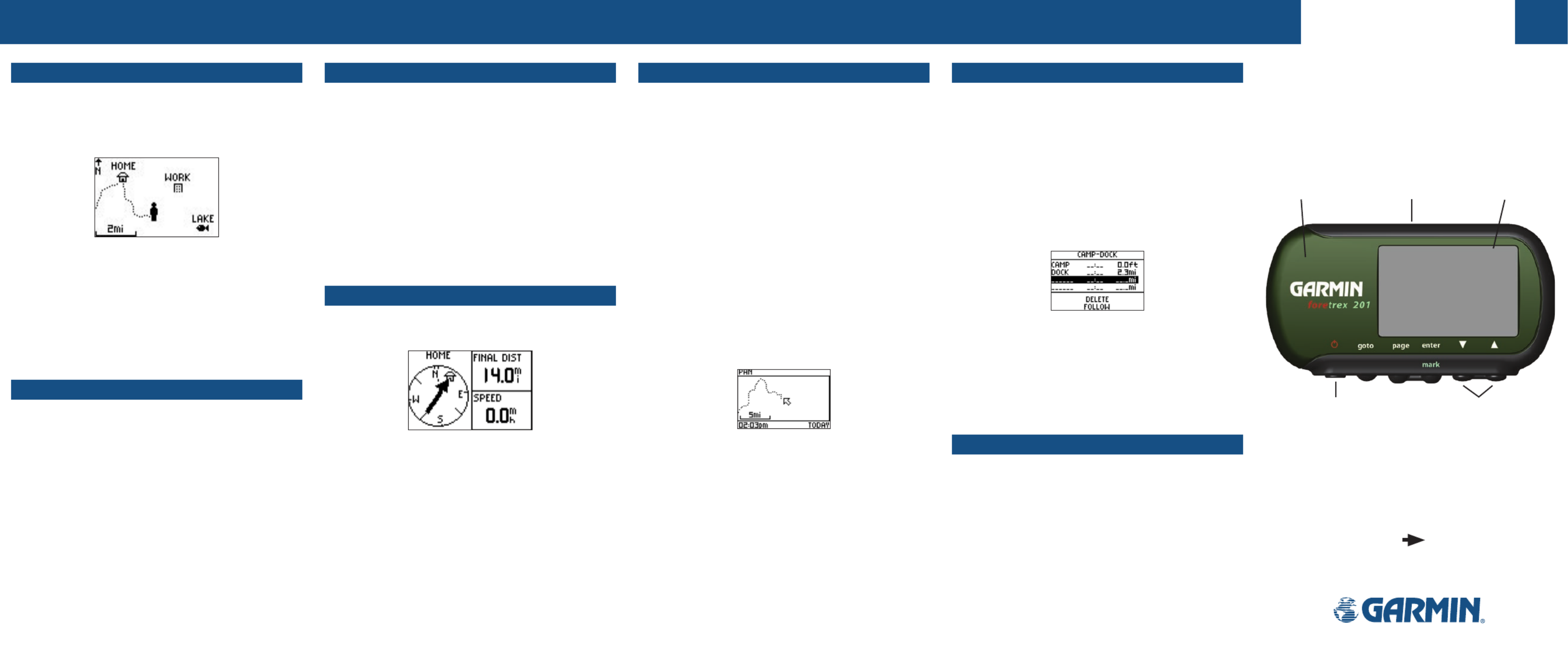
Using Routes
Route navigation allows you to create a sequence of waypoints to
lead you to your final destination.
To create a route:
1. From the Main Menu Page press the or button to UP DOWN
highlight ‘ROUTES’, then press the button.ENTER
2. Select ‘CREATE NEW’ and press . Press to display ENTER ENTER
the ‘ADD POINT TO ROUTE PAGE’.
3. Use the UP/DOWN ENTER and buttons to select the desired
waypoint and press . Repeat until all of the desired ENTER
waypoints are in the route.
Route Page
The route is automatically named with the first waypoint and
the last waypoint, such as Camp-Dock. Press PAGE to exit the
Route Page and return to the Route Menu. Use the and UP DOWN
buttons to highlight ‘DELETE’ and press to delete the entire ENTER
route. Use the and buttons to highlight ‘FOLLOW’ and UP DOWN
press to follow the route.ENTER
Using the Timer
After the Timer Page is enabled and a count down time is
entered, you can use the timer for a variety of applications, such as
running and sailboat racing. The synchronization and quick reset
capabilities make the Foretrex an extremely handy timer.
To stop and start the timer:
1. Press the PAGE button until the Timer Page is displayed.
2. To start the timer, press the ENTER button when ‘START’ is
displayed along the bottom of the page.
3. To stop the timer, press the ENTER button when ‘STOP’ is
displayed along the bottom of the page.
Step-by-Step Instructions
to Get You Started
(Turn this page and begin with Step 1)
*Flip this Quick Start
Guide over for a
detailed explanation
of the Foretrex 201
buttons.
Waterproof
Case
LCD Display
(with Backlight)
Built-in GPS
Antenna
Power Button
(Backlight)
Up/Down
Buttons
Part Number 190-00353-01 Rev B
Foretrex 201 Features Foretrex 201 Features Foretrex 201 Features Foretrex 201 Features
Produkt Specifikationer
| Mærke: | Garmin |
| Kategori: | Navigator |
| Model: | Foretrex 201 |
| Bredde: | 84 mm |
| Dybde: | 18 mm |
| Højde: | 43 mm |
| Vægt: | 78 g |
| Skærmopløsning: | 100 x 64 pixel |
| Bluetooth: | Ingen |
| Batteriteknologi: | Lithium-Ion (Li-Ion) |
| Formfaktor: | Håndholdt |
| Driftstemperatur (T-T): | -20 - 60 °C |
| Skærm: | LCD |
| Batterilevetid (maks.): | 15 t |
| Skærmstørrelse (HxL) (britisk standard): | 1.44 x 0.92 " |
| Grænseflade: | RS232 + NMEA 0183 |
| Marine (kortplottere, ekkolod): | Ingen |
| Sport (fitness, løb): | Ingen |
| Udendørs (vandring, trekking): | Ja |
| Geocaching (GPS stash hunt): | Ingen |
| Automatisk: | Ingen |
| Luftfart: | Ingen |
| Antal ruter: | 20 |
| Antal styringspunkter: | 500 |
| Synkroniseringstid - kold: | 45 sek./side |
| GPS nøjagtighed - position: | 3 m |
| Baggrundskort: | Ingen |
| WAAS-kapacitet: | Ja |
| Synkroniseringstid - varm: | 15 sek./side |
Har du brug for hjælp?
Hvis du har brug for hjælp til Garmin Foretrex 201 stil et spørgsmål nedenfor, og andre brugere vil svare dig
Navigator Garmin Manualer

10 Januar 2025
30 December 2025
14 November 2024
11 Oktober 2024
30 September 2024
29 September 2024
24 September 2024
24 September 2024
24 September 2024
22 September 2024
Navigator Manualer
- Navigator SilverCrest
- Navigator Acer
- Navigator Honda
- Navigator BMW
- Navigator Toyota
- Navigator Opel
- Navigator Sony
- Navigator Mazda
- Navigator Audi
- Navigator Volkswagen
- Navigator Philips
- Navigator Pioneer
- Navigator Kenwood
- Navigator Lowrance
- Navigator HP
- Navigator Harman Kardon
- Navigator Becker
- Navigator Sanyo
- Navigator Grundig
- Navigator Volvo
- Navigator Motorola
- Navigator Asus
- Navigator Bushnell
- Navigator Pyle
- Navigator Humminbird
- Navigator Sygic
- Navigator Thomson
- Navigator Skoda
- Navigator Nokia
- Navigator Mio
- Navigator Blaupunkt
- Navigator JVC
- Navigator Uniden
- Navigator Hitachi
- Navigator Medion
- Navigator Alpine
- Navigator Navman
- Navigator Parrot
- Navigator Packard Bell
- Navigator Kapsys
- Navigator Zebra
- Navigator Jensen
- Navigator VDO
- Navigator Zenec
- Navigator Kalkhoff
- Navigator TomTom
- Navigator Cobra
- Navigator Binatone
- Navigator Dual
- Navigator GlobalSat
- Navigator Celestron
- Navigator Overmax
- Navigator Midland
- Navigator Alfa Romeo
- Navigator Raymarine
- Navigator Simrad
- Navigator MaxCom
- Navigator Chrysler
- Navigator Furuno
- Navigator Navitel
- Navigator Caliber
- Navigator Lark
- Navigator Teasi
- Navigator GoClever
- Navigator Clarion
- Navigator V7
- Navigator Airis
- Navigator Audiovox
- Navigator Rand McNally
- Navigator Navigon
- Navigator IGo
- Navigator Magellan
- Navigator Scosche
- Navigator Prestigio
- Navigator Boss
- Navigator Camos
- Navigator Coyote
- Navigator Insignia
- Navigator Eagle
- Navigator Xomax
- Navigator Sylvania
- Navigator Marquant
- Navigator Lanzar
- Navigator GolfBuddy
- Navigator Soundstream
- Navigator VDO Dayton
- Navigator Dashmate
- Navigator Route 66
- Navigator Falk
- Navigator Seecode
- Navigator Nav N Go
- Navigator Pharos
- Navigator Viamichelin
- Navigator ModeCom
- Navigator Xzent
- Navigator CarTrek
- Navigator Whistler
- Navigator ESX
- Navigator Dynavin
- Navigator Cheetah
- Navigator Cydle
- Navigator LXNAV
- Navigator Planet Audio
- Navigator Eclipse
- Navigator Voice Caddie
- Navigator SkyCaddie
- Navigator TELE System
- Navigator IZZO Golf
- Navigator Zoleo
- Navigator Izzo
Nyeste Navigator Manualer

18 Januar 2025
31 December 2025
29 December 2024
29 December 2024
14 December 2024
14 December 2024
8 December 2024
8 December 2024
24 November 2024
13 November 2024