Garmin GPSMAP 2206 Manual
Læs nedenfor 📖 manual på dansk for Garmin GPSMAP 2206 (106 sider) i kategorien Navigator. Denne guide var nyttig for 14 personer og blev bedømt med 4.5 stjerner i gennemsnit af 2 brugere
Side 1/106

GPSMAP
Owner’s Manual
2206/2210

© 2006 Garmin Ltd. or its subsidiaries
Garmin International, Inc.
1200 East 151
st
Street,
Olathe, Kansas 66062, USA
Tel. (913) 397.8200 or (800) 800.1020
Fax (913) 397.8282
Garmin (Europe) Ltd.
Unit 5, The Quadrangle,
Abbey Park Industrial Estate,
Romsey, SO51 9DL, UK
Tel. +44 (0) 870.8501241 (outside the UK)
0808 2380000 (within the UK)
Fax +44 (0) 870.8501251
Garmin Corporation
No. 68, Jangshu 2
nd
Road,
Shijr, Taipei County, Taiwan
Tel. 886/2.2642.9199
Fax 886/2.2642.9099
All rights reserved. Except as expressly provided herein, no part of this manual may be reproduced, copied, transmitted, disseminated, downloaded or stored in any storage medium, for any
purpose without the express prior written consent of Garmin. Garmin hereby grants permission to download a single copy of this manual onto a hard drive or other electronic storage medium to
be viewed and to print one copy of this manual or of any revision hereto, provided that such electronic or printed copy of this manual must contain the complete text of this copyright notice and
provided further that any unauthorized commercial distribution of this manual or any revision hereto is strictly prohibited.
Information in this document is subject to change without notice. Garmin reserves the right to change or improve its products and to make changes in the content without obligation to notify any
person or organization of such changes or improvements. Visit the Garmin Web site (www.garmin.com) for current updates and supplemental information concerning the use and operation of this
and other Garmin products.
Garmin
®
is a trademark of Garmin Ltd. or its subsidiaries, registered in the USA and other countries. Garmin®, GPSMAP®, AutoLocate®, TracBack®, BlueChart®, BlueChart® g2™ and
MapSource®, SeeThru®, DynaColor™, and UltraScroll™ are trademarks of Garmin Ltd. or its subsidiaries. These trademarks may not be used without the express permission of Garmin.
November 2006 Part Number 190-00678-00 Rev. D Printed in Taiwan

GPSMAP 2206/2210 Owner’s Manual i
I > ntroductIon A M M cbout thIs AnuAl And AnuAl onventIons
IntroductIon
Thank you for choosing the Garmin
®
GPSMAP
®
2206/2210. The
GPSMAP 2206/2210 uses the proven performance of Garmin GPS and
full-featured mapping to create an unsurpassed marine Multi-Function Display
(MFD). The GPSMAP 2206/2210 is a non-network chartplotter that comes
preloaded with detailed marine cartography using BlueChart
®
g2 technology.
Built-in coverage is provided for U.S. coastal areas, including Alaska and Hawaii.
Both units accept up to two optional data cards for loading additional map
coverage of inland lakes or BlueChart
®
detail for other regions. Take a moment
now to compare the contents of this package with the packing list on the outside
of the box. If any pieces are missing, contact your Garmin dealer immediately.
Installing Your GPSMAP 2206/2210
To install the GPSMAP 2206/2210, refer to the GPSMAP 2206/2210 & GPS 17
Installation Instructions. To complete the installation, you need the appropriate
fasteners, tools, and mounts listed in each section. Installation items not provided
by Garmin should be available at most marine dealers. If you experience
difculty installing the unit, contact Garmin Product Support or an installation
professional in your area.
The GPSMAP 2206/2210 is CANet compatible. See the GPSMAP 2206/2210 &
GPS 17 Installation Instructions .for more information
About This Manual
To get the most out of your new chartplotter, read this manual and learn the
operating procedures for your unit in detail. This manual is organized into the
following sections:
The contains the Table of Contents, Product Registration, and the Introduction
Software License Agreement.
The section provides a unit overview and information that Getting Started
provides basic working knowledge needed to use the GPSMAP 2206/2210.
The section provides you with details and step-by-step Basic Operation
instructions such as creating and using waypoints, navigating a route, and using
the key. FIND
The section provides detailed explanations about each page in the Main Pages
GPSMAP 2206/2210 and step-by-step directions on using the pages.
The section provides detailed explanations about the Main Menu Main Menu
and how to use it to congure your unit.
See the section if you have either a Garmin GSD 21 or GSD 22 Using Sonar
sounder connected to your GPSMAP 2206/2210.
The Appendix contains specications, regulatory information, unit care
information, optional accessories, and maintenance information. You can also nd
warranty and FCC information in the Appendix.
An is provided at the end of the manual for reference.Index
Manual Conventions
This manual uses the term Warning to indicate a potentially hazardous situation,
which, if not avoided, could result in death or serious injury.
This manual uses the term to indicate a potentially hazardous situation, Caution
which, if not avoided, may result in minor injury or property damage. It may also
be used without the symbol to alert you to avoid unsafe practices.

iv GPSMAP 2206/2210 Owner’s Manual
I > ntroductIon t cAble of ontents
Appendix ................................................................................................ 82
Specications ............................................................................................... 82
Installing and Removing Data Cards .......................................................... 83
What is WAAS/EGNOS? ...............................................................................84
WAAS Capability ..........................................................................................84
Digital Selective Calling (DSC) .................................................................... 85
What is DSC? .........................................................................................................85
LORAN TD System ....................................................................................... 86
Caring for the GPSMAP 2206/2210 ............................................................. 87
Navigation Terms.......................................................................................... 88
Messages and Alarms .................................................................................. 90
Optional Accessories ................................................................................... 92
Limited Warranty .......................................................................................... 93
FCC Compliance ........................................................................................... 94
Declaration of Conformity (DoC) ................................................................ 94
Index ....................................................................................................... 95

Product Registration
Help us better support you by completing our online registration today! Connect
to our Web site at www.garmin.com/registration/.
Use this area to record the serial number (8-digit number located on the back of
the GPSMAP 2206/2210) in case your GPSMAP 2206/2210 needs service. Keep
the original sales receipt, or a photocopy, in a safe place.
Serial Number: ___ ___ ___ ___ ___ ___ ___ ___
Contact Garmin
Contact Garmin if you have any questions while using your GPSMAP 2206/2210.
In the U.S.A. contact Garmin Product Support by phone: 913/397.8200 or
800/800.1020, Monday–Friday, 8 AM–5 PM Central Time; or go to
www.garmin.com/support/, and click .Product Support
In Europe, contact Garmin (Europe) Ltd. at 44/0870.8501241.
Software License Agreement
BY USING THE GPSMAP 2206/2210, YOU AGREE TO BE BOUND BY THE
TERMS AND CONDITIONS OF THE FOLLOWING SOFTWARE LICENSE
AGREEMENT. PLEASE READ THIS AGREEMENT CAREFULLY.
Garmin grants you a limited license to use the software embedded in this device
(the “Software”) in binary executable form in the normal operation of the product.
Title, ownership rights, and intellectual property rights in and to the Software
remain in Garmin.
You acknowledge that the Software is the property of Garmin and is protected
under the United States of America copyright laws and international copyright
treaties. You further acknowledge that the structure, organization, and code of
the Software are valuable trade secrets of Garmin and that the Software in source
code form remains a valuable trade secret of Garmin. You agree not to decompile,
disassemble, modify, reverse assemble, reverse engineer, or reduce to human
readable form the Software or any part thereof or create any derivative works
based on the Software. You agree not to export or re-export the Software to any
country in violation of the export control laws of the United States of America.
GPSMAP 2206/2210 Owner’s Manual v
I > ntroductIon P rroduct egIstrAtIon And oftwAre Icense s l AgreeMent

vi GPSMAP 2206/2210 Owner’s Manual
I > ntroductIon wArnIngs
Failure to avoid the following potentially hazardous situations could result in an
accident or collision resulting in death or serious injury.
• When navigating, carefully compare information displayed on the unit to all
available navigation sources, including information from visual sightings, and
maps. For safety, always resolve any discrepancies or questions before continuing
navigation.
• Use the electronic chart in the unit only to facilitate, not to replace, the use of
authorized government charts. Ofcial government charts and notices to mariners
contain all information needed to navigate safely.
• Use this unit only as a navigational aid. Do not attempt to use the unit for any
purpose requiring precise measurement of direction, distance, location, or
topography.
WARNING: This product, its packaging, and its components contain chemicals known to the State of California to cause cancer, birth defects, or reproductive harm. This Notice is provided in
accordance with California’s Proposition 65. See www.garmin.com/prop65 for more information.
Warnings
Important Information
MAP DATA INFORMATION: One of the goals of Garmin is to provide customers with the most complete and accurate cartography that is available to us at a reasonable cost. We use a
combination of governmental and private data sources, which we identify in product literature and copyright messages displayed to the consumer. Virtually all data sources contain some
inaccurate or incomplete data. In some countries, complete and accurate map information is either not available or is prohibitively expensive.
The California Electronic Waste Recycling Act of 2003 requires the recycling of certain electronics. For more information on the applicability to this product, see www.erecycle.org.
Hg - LAMP(S) INSIDE THIS PRODUCT MAY CONTAIN MERCURY AND MUST BE RECYCLED OR DISPOSED OF ACCORDING TO LOCAL, STATE, OR
FEDERAL LAWS.
For more information go to:
www.garmin.com/aboutGarmin/environment/disposal.jsp.

GPSMAP 2206/2210 Owner’s Manual 1
g settIng tArted > u onIt vervIew
15)4
%.4%2
-!2+
0!'%
&).$
!$*
-%.5
$!4!
#.&'
.!6
-/"
!"#
$%&
'()
*+,
-./
0123
456
789:
>>>>>
://-
G settInG tarted
Unit Overview
Soft key buttons
Data entry keys
Data card slots
Interface keys
Data card slot 1
Data card slot 2
GPSMAP 2210 Shown
Connection ports
Serial number tag
GPSMAP 2206/2210 Owner’s Manual 3
g settIng tArted > u gPsMAP 2206/2210 KsIng the eyPAd
Using Soft Keys
Soft keys are located along the bottom of the display and are used as shortcuts to
select the most commonly used options for the selected page, window, or tab. To
select a soft key, press the soft key button ( ) directly below it.
>>>>>
Soft keys
Using Data Entry/Shortcut Keys
Use the data entry keys to enter alphanumeric data into the unit, such as a
waypoint name. Use data entry keys in conjunction
with the . Press the key once to select the ROCKER
rst letter on the key, twice to select the second letter
on the key, three times to select the third letter on the
key, or four times to select the number on the key.
For keys 7, 8, and 9, press the key ve times to select
the number on the key. When you have selected the
correct letter or number, pause, and the unit advances
the cursor to the next character automatically.
Use the shortcut keys to jump to main pages,
or select menu and list options by pressing the
corresponding number of the selection. For numbers 1-9, press the number to
choose the selection. For numbers 10 and higher, press the rst digit, then press
the second digit within one second.
Status Bar
At the top of each page, the status bar provides current status information for
connected devices and several of the MFD functions.
Status bar
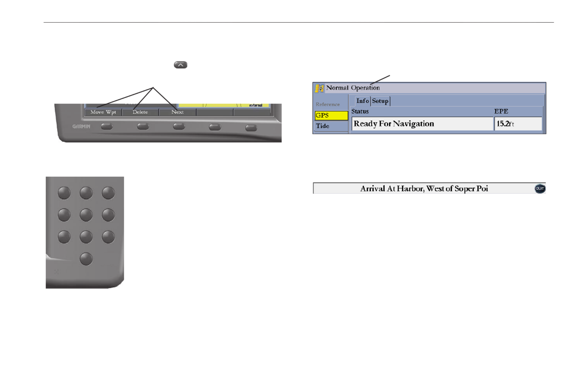
Alarm alerts also appear on the status bar. To acknowledge an alarm, press QUIT.
If an alarm condition persists, it appears on the status bar until the alarm condition
no longer exists. For more information about alarms, see pages .56-58
!"#
$%&
'()
*+,
-./
0123
456
789:

4 GPSMAP 2206/2210 Owner’s Manual
g settIng tArted > t gPsMAP 2206/2210urnIng on the
Turning on the GPSMAP 2206/2210
Before you turn on the GPSMAP 2206/2210, make sure the unit and GPS 17
antenna are correctly installed on your vessel according to the instructions in the
GPSMAP 2206/2210 & GPS 17 Installation Instructions.
The rst time you turn on the GPSMAP 2206/2210, the GPS 17 receiver
must collect satellite data and determine its current location. To ensure proper
initialization, the GPSMAP 2206/2210 is shipped from the factory in AutoLocate
mode.
To turn on the GPSMAP 2206/2210:
1. Press and hold the key until the unit turns on.POWER
2. When I Agree is highlighted on the Warning Page, press to open ENTER
the Map Page.
NOTE: The rst time you turn on the unit, you are asked if you want to start
the retail demonstration. Select , and press .No ENTER
To turn off the GPSMAP 2206/2210:
Press and hold the key until the unit turns off.POWER
Adjusting the Backlight
You can adjust the screen backlighting on the GPSMAP 2206/2210 from any
page by using the key.POWER/BACKlIGhT
To adjust the backlight level:
1. Press and release the key. POWER/BACKLIGHT
2. Press up on the to increase the brightness, or press down to ROCKER
decrease.
After you open the Backlight adjustment window, press the TIP:
POWER/BACKlIGhT key repeatedly to cycle through the three
backlight settings: Highest, Middle, and Lowest.
Highest Middle Lowest
3. Press or to close the Backlight adjustment window.ENTER QUIT

GPSMAP 2206/2210 Owner’s Manual 5
g settIng tArted > I gPs rnItIAlIzIng the eceIver
Initializing the GPS Receiver
When you turn on the GPSMAP 2206/2210, a Warning Page appears, showing
unit information, network connections (attached devices), and important
information regarding the proper use of the unit. It takes a few seconds for the
GPSMAP 2206/2210 to search for attached devices. When the search is complete,
the I Agree button is highlighted. After reading the warning, press .ENTER
Next, you see the rst of the main pages, the Map Page. The GPSMAP 2206/2210
begins searching for GPS satellites. The rst time the unit acquires satellites takes
several minutes. Afterward, acquisition times are quicker during normal use. The
GPS status icon on the left side of the status bar shows the progress of the satellite
acquisition process.
GPS status icon colors are:
• Red—acquiring satellites/lost satellite reception.
• Orange—ready for navigation/ready for navigation with WAAS.
• Gray—lost GPS connection. (Check GPS antenna wiring connections.)
A detailed visual reference of the satellite acquisition, GPS receiver status, and
accuracy is available on the tab on the Main Menu. GPS
To view the GPS tab information:
1. Press and hold to open the Main Menu.ADJ/MENU
2. Use the to highlight the tab. ROCKER GPS
When viewing the GPS Info sub tab, a signal strength bar for each satellite in
view appears on the right of the page, with the appropriate satellite number
underneath each bar. The numbers below each bar represent the particular satellite
that is being received. Numbers above 33 indicate WAAS satellites. For more
information about WAAS, see the “ .”Appendix
The sky view shows a birds-eye view of the location of each satellite relative to
the receiver’s last known location. The outer circle represents the horizon (north
up), the inner circle 45º above the horizon, and the center point a location directly
overhead. You can also set the sky view to track up, which causes the top of the
sky view to align along your current track heading.
GPS Tab
Status eld
GPS status
icon
Status bar
The progress of satellite acquisition is shown in three stages:
• No signal strength bars—the receiver is looking for the satellites
indicated.
• Hollow signal strength bars—the receiver has found the indicated
satellite(s) and is collecting data.
• Solid green signal strength bars—the receiver has collected the necessary
data and the satellite(s) are ready for use.
Produkt Specifikationer
| Mærke: | Garmin |
| Kategori: | Navigator |
| Model: | GPSMAP 2206 |
| Bredde: | 262 mm |
| Dybde: | 84 mm |
| Højde: | 165 mm |
| Vægt: | 1360 g |
| Skærmopløsning: | 640 x 480 pixel |
| Berøringsskærm: | Ingen |
| Bluetooth: | Ingen |
| Formfaktor: | Plug-in |
| Marine (kortplottere, ekkolod): | Ja |
| Sport (fitness, løb): | Ingen |
| Udendørs (vandring, trekking): | Ingen |
| Geocaching (GPS stash hunt): | Ingen |
| Automatisk: | Ingen |
| Luftfart: | Ingen |
| Antal ruter: | 50 |
| Antal styringspunkter: | 3000 |
| Baggrundskort: | Ja |
Har du brug for hjælp?
Hvis du har brug for hjælp til Garmin GPSMAP 2206 stil et spørgsmål nedenfor, og andre brugere vil svare dig
Navigator Garmin Manualer

10 Januar 2025
30 December 2025
14 November 2024
11 Oktober 2024
30 September 2024
29 September 2024
24 September 2024
24 September 2024
24 September 2024
22 September 2024
Navigator Manualer
- Navigator SilverCrest
- Navigator Acer
- Navigator Honda
- Navigator BMW
- Navigator Toyota
- Navigator Opel
- Navigator Sony
- Navigator Mazda
- Navigator Audi
- Navigator Volkswagen
- Navigator Philips
- Navigator Pioneer
- Navigator Kenwood
- Navigator Lowrance
- Navigator HP
- Navigator Harman Kardon
- Navigator Becker
- Navigator Sanyo
- Navigator Grundig
- Navigator Volvo
- Navigator Motorola
- Navigator Asus
- Navigator Bushnell
- Navigator Pyle
- Navigator Humminbird
- Navigator Sygic
- Navigator Thomson
- Navigator Skoda
- Navigator Nokia
- Navigator Mio
- Navigator Blaupunkt
- Navigator JVC
- Navigator Uniden
- Navigator Hitachi
- Navigator Medion
- Navigator Alpine
- Navigator Navman
- Navigator Parrot
- Navigator Packard Bell
- Navigator Kapsys
- Navigator Zebra
- Navigator Jensen
- Navigator VDO
- Navigator Zenec
- Navigator Kalkhoff
- Navigator TomTom
- Navigator Cobra
- Navigator Binatone
- Navigator Dual
- Navigator GlobalSat
- Navigator Celestron
- Navigator Overmax
- Navigator Midland
- Navigator Alfa Romeo
- Navigator Raymarine
- Navigator Simrad
- Navigator MaxCom
- Navigator Chrysler
- Navigator Furuno
- Navigator Navitel
- Navigator Caliber
- Navigator Lark
- Navigator Teasi
- Navigator GoClever
- Navigator Clarion
- Navigator V7
- Navigator Airis
- Navigator Audiovox
- Navigator Rand McNally
- Navigator Navigon
- Navigator IGo
- Navigator Magellan
- Navigator Scosche
- Navigator Prestigio
- Navigator Boss
- Navigator Camos
- Navigator Coyote
- Navigator Insignia
- Navigator Eagle
- Navigator Xomax
- Navigator Sylvania
- Navigator Marquant
- Navigator Lanzar
- Navigator GolfBuddy
- Navigator Soundstream
- Navigator VDO Dayton
- Navigator Dashmate
- Navigator Route 66
- Navigator Falk
- Navigator Seecode
- Navigator Nav N Go
- Navigator Pharos
- Navigator Viamichelin
- Navigator ModeCom
- Navigator Xzent
- Navigator CarTrek
- Navigator Whistler
- Navigator ESX
- Navigator Dynavin
- Navigator Cheetah
- Navigator Cydle
- Navigator LXNAV
- Navigator Planet Audio
- Navigator Eclipse
- Navigator Voice Caddie
- Navigator SkyCaddie
- Navigator TELE System
- Navigator IZZO Golf
- Navigator Zoleo
- Navigator Izzo
Nyeste Navigator Manualer

18 Januar 2025
31 December 2025
29 December 2024
29 December 2024
14 December 2024
14 December 2024
8 December 2024
8 December 2024
24 November 2024
13 November 2024